
the 10 best hikes in the Black Hills
Short scrambles to challenging climbs— this post contains the 10 best hikes for travellers in the Black Hills.
I spent my high school years cliff jumping into chilly lake waters, running down dirt trails, and hiking around the Black Hills in South Dakota. Moments spent outdoors in the Black Hills helped to shape my love of nature, especially mountain and forest landscapes. It’s that love of the area’s trails and tracks that has helped me cultivate this list of the 10 best hikes in the Black Hills.
I haven’t written much about South Dakota, and that’s a real shame. I think for a long time I was so glad to leave and then got so caught in with international travel, that I often forget how much I love Rapid City and the Black Hills area. The connection I feel to the place is often cloudy in my memory. Despite finding more of a home in other destinations, this part of SoDak is special to me, and houses a lot of cherished moments— many of them on trails in the hills.
Hopefully, this guide will give you all the information you need to make your own memories hiking in the Black Hills.
how to support the tribal nations of South Dakota
Before you start hiking, it feels necessary to start this post by addressing that the trails you’ll be enjoying rightfully belong to the Tribal Nations of South Dakota, as the land was stolen from them.
The Black Hills, known as Paha Sápa or He Sápa {Black Mountains} to many Tribal Nations, is located in South Dakota. This area is the spiritual and ancestral home of many tribes, primarily the Lakota and Dakota nations. To put it into better perspective, South Dakota, the state holding the Black Hills is home to an estimated 71,800 Native Americans. Within the state resides 9 Tribal Governments, 7 of which have reservation boundaries. There are a number of problematic issues surrounding Tribal Nations, including the fact that Tribes must be defined by the State or Federal Government in order to “exist”.
A visit to the Black Hills, especially to hike on its many trails, is the perfect opportunity to do your part. The simplest way to support Indigenous communities while visiting the Black Hills is to seek out Native-owned businesses. This website is a great resource to help keep the money you’re spending funneled directly to the Indigenous communities.
Having an ethical tourism experience is always my goal, and this includes following local rules, getting off the tourist track, spending my dollars to support local businesses, and opting for sustainable travel alternatives.
Some quick + easy ways to support Indigenous communities as a hiker in the Black Hills:
buy your hiking snacks from a Native-owned store
don’t litter or damage the trails you hike on
don’t pick or damage plant species native to the area
respect signs and follow trail rules

the Black Hills’ best hikes
Harney Peak/ Black Elk Peak
I would be remiss to not kick off this post with Black Elk Peak, formerly known as Harney Peak. Black Elk Peak is a staple for hiking enthusiasts visiting the Black Hills thanks to it being the highest natural point in South Dakota. This 7,000+ foot of granite mountain is topped with a stone fire tower that is no longer in use {I’m sitting on its walls on the picture to the left}.
The last half-mile is rockier than the rest of the trail. While it’s definitely one of the harder hikes in terms of distance and elevation, this is a family-friendly hike that even beginner hikers can do if they allow themselves the time.
You might consider bringing microspikes or poles with you if you are doing it in the early Spring.
Parking by the trailhead | Approximately 4 miles away from Mount Rushmore, there is a free parking lot on the left near the trailhead sign.
Total distance | ~8 miles
Trail type | loop
Elevation | 1,551 feet
Sunday Gulch Trail
Sunday Gulch Trail begins near Sylvan Lake, a SoDak favourite in the summertime. As you head out on your hike, you’ll make your way down big boulders down a vallery. The trail itself can be quite steep in places, but there are handrails in place to help you get down the giant boulders at the beginning. There is a creek that flows alongside the half the trail, so be prepared to get a little wet depending on the season you hike. As you are hiking along you’ll see a number of small {but still beautiful} waterfalls along the trail, which make for pretty photo opportunities and are little reminders of the beauty you are enveloped in.
Parking by the trailhead | Walk around Sylvan Lake to the Northwest corner. From there, you will see a sign for Sunday Gulch Trail, it’s marked Trail #6. There is a parking lot by the trailhead and bathrooms, a gift shop, and restaurants there for visitors to pop into before or after the hike.
Total distance | 4 miles
Trail type | loop
Elevation | 797 feet
Poet’s Table
Poet’s Table might be one of my favourite hikes in the Black Hills simply because it’s an outdoor mystery! If you don’t want to deal with the crowds that often form up Harney Peak, this is a quieter alternative with equally fantastic views. It also takes less time to hike, so it’s great if you’re trekking on a time crunch. Poet’s Table hike starts at the Little Devil’s Tower Trailhead to the east of Sylvan Lake, but I don’t want to give away too many of the specifics. Part of the fun of this trek is that it leads to a green table with green chairs scattered around it. There is a matching green cabinet to the side filled with books and mementos from those adventurers who hiked it before you.
Please note: part of the beauty of Poet’s Table is that it’s exact location is not revealed. If you do find it, please do not spoil it for future hikers by blogging about it, creating a Maps.Me gep pin, etc.

Flume Trail
Okay, so here’s the truth: this trail’s markings are horrendous. It’s not well marked and what signage does exist is often hard to find. Flume Trail is near Rapid City. The trail leads you straight to Sheridan Lake, the perfect reward after a 12.5-mile hike. The trail was used to carry water to the gold miners near Rockerville in the 1880s. Walking the entire length of the trail would be like walking a marathon, but you can do the trail as a point-to-point hike.
Parking by the trailhead | To get there, take U.S. Highway 385 to Sheridan Lake Campground. From the campground, follow signs to the Calumet Trailhead.
Total distance | ~23 miles
Trail type | out-and-back
Elevation | 1,351 feet
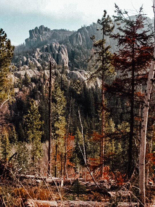
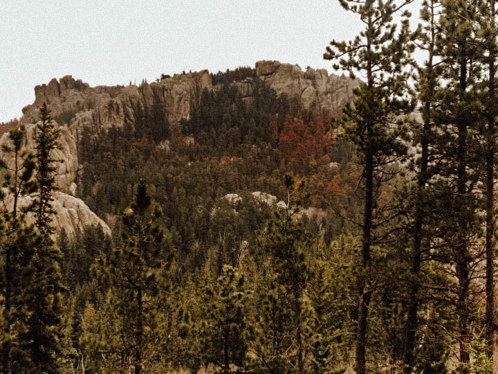
Cathedral Spires Trail
The Cathedral Spires Trail crosses 3 miles of beautiful Black Hills ground and is often used by rock climbers to get to some of the best climbing in the black Hills. Hikers get to pass by spire structures and the state park prairie lands. To be totally honest, the end of the trail is a bit anticlimactic. However, locals know that if you make your way around the giant rocks at the summit, you’ll reach a viewpoint.
Parking by the trailhead | There is a free parking lot with limited spots just to the right of the trailhead.
Total distance | 3 miles
Trail type | out-and-back
Elevation | 490 feet
Lover’s Leap Trail
Lover's Leap Trail offers views of Cathedral Spires, Black Elk Peak and Mount Coolidge. The trail gets its name from Indigenous folklore. According to the tale, a Native woman and her lover jumped from the summit of the hike, falling to their deaths.
The trail is relatively challenging for hikers due to multiple creek crossings and a steep incline on the first portion, so good shoes are a smart idea.
Parking by the trailhead | There is a free carpark off the Highway 16A next to the trailhead.
Total distance | 4.2 miles
Trail type | loop
Elevation | 626 feet
Horsethief Lake Trail
Horsethief Lake Trail is located behind Horsethief Lake {thus the trail’s name}. If you’re looking for mountain goodness, Horsethief Lake may be the trail for you. The trail is quite rocky, so proper boots are best for ankle support, but it is doable with solid trainers. You’ll pass by waterfalls, granite spires, and giant boulders as you hike through the forest.
Parking by the trailhead | There is a free-to-use parking lot just off Horsethief Lake Road. The trailhead is easily seen from the car park.
Total distance | 5.3 miles
Trail type | out-and-back
Elevation | 1,102 feet

Hippie Hole
Hippie Hole is one of my absolute favourite hikes in the Black Hills, riddled with nostalgia. The hike leads to a waterfall and a swimming hole and takes hardly any time at all. You can approach Hippie Hole from two directions. There is the option for a short hike that leads you down Battle Creek starting at a small parking area near South Rockerville Road, or you can go on a more strenuous hike that starts off of State Highway 40.
Parking by the trailhead | The dirt road leading to the trailhead is full of dips and rocks. It’s best to have a high clearance vehicle, honestly, as the road to the trailhead is a lot like off-roading.
Total distance | 1.5 miles
Trail type | out-and-back
Elevation | 452 feet
Crow Peak Trail
Crow Peak Trail is roughly a 7-mile {roundtrip} out-and-back near Spearfish. There is an incredible view of Bear Butte to the east of the trail. Don’t miss the Crow Peak Brewery when you finish your hike! The craft beers are some of my favourite and there is often live music to add to the atmosphere.
Parking by the trailhead | Approximately 7-miles from Spearfish, there is a small parking area that’s free to use West of the trailhead. The trailhead sign is somewhat hidden, roughly 20-30 yards from the parking lot.
Total distance | ~7 miles
Trail type | out-and-back
Elevation | 1,568 feet
Buzzard’s Roost
Buzzard’s Roost is probably only making this list due to the nostalgia and romance I attach to it. Then again, it’s not just me who thinks it makes for a nice hike— the trail sees a lot of foot traffic, especially from locals. I used to bring my puppy here to let her roam free while Nathan and I hiked up to the lookout. It can get a bit muddy, so make sure you’re prepared and check the weather before you hit the trail.
Parking by the trailhead | Buzzard’s Roost is just 4-miles West of Rapid City on Highway 44. There is a free parking area on the left after the Black Hills National Forest sign.
Total distance | 2.2 miles
Trail type | loop
Elevation | 469 feet
hiking gear
I put essential in quotations, because we used to dirtbag these trails in running shoes with Nalgene bottles. However, as we all grew up, earned a decent wage, and {perhaps} wisened up, we started to collect proper hiking gear {boots, snow clips, etc.}. What I love about hiking is that you don’t necessarily need a lot of gear and it doesn’t have to be expensive, especially starting out.
Here’s my short list of suggested gear:
hiking boots: I love my Columbia boots {similar here}
reusable water bottle {filled}: I use a LifeStraw bottle or a Nalgene
sunscreen
daypack: I use an Osprey 20L
snacks: Some of my favourites are Goldfish crackers, Clif Bar, RX Bars, and VegeBears
map ↴
Find the best hikes in the Black Hills, South Dakota on the map below.


